map of vancouver neighbourhoods
Download a PDF of this map here.
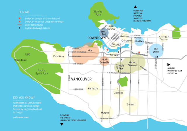
Our recommendations Close to the school and accessible by public transit, bike or by foot. These areas are safe, fun, close to restaurants and nightlife and are where locals live in the core of Vancouver.
WEST
South Granville – beautiful walk-up buildings, close to lovely boutique shops and restaurants, along major transit routes, and within walking distance to campus
Kitsilano – close to the beach, with stellar views, leftover hippie culture, and a short bike ride to school along the seawall
IN THE MIDDLE
Mount Pleasant/Cambie Village – some of the best shopping and dining in the city, shared heritage houses, great for coffee lovers, and central location with easy access to Granville Island and downtown
EAST VAN
Strathcona – houses oozing with charm, near bustling areas of Chinatown and Gastown, artsy vibe, on Adanac bike route direct to campus
Commercial Drive – slam poetry, Italian and Portuguese flavour, organic food, laid back, lots of great cafés
DOWNTOWN
The West End – beaches surround this quiet, friendly, walkable neighbourhood, lots of little dogs, restaurants and bars, close to Stanley Park and a massive outdoor pool, and a short ferry ride (yes ferry!) to school
OTHER AREAS OF VANCOUVER
Cheaper Rents, Longer Commutes – Oakridge, Marpole, Sunset (on Canada Line), and Hastings-Sunrise (not on Canada line) thecanadaline.com
Money is No Object – West Vancouver, Point Grey, Kerrisdale, Dunbar, UBC, Coal Harbour
City Vibe – Gastown, Chinatown, Yaletown

DID YOU KNOW?
![]()
Studio class sizes are capped to small numbers, in order to promote one-on-one interaction with your instructors, and a friendly and cooperative working atmosphere with your classmates.
DID YOU KNOW?
![]()
Skateboarders rejoice! There are nearly 120 skate parks in the Greater Vancouver area, where you’ll find bowls, ramps, hipboxes and street-style layouts.